Choquequirao Ruins, the other Machu Picchu
Choquequirao, often dubbed as the «sister city» to the renowned Machu Picchu, stands as a testament to the remarkable architectural prowess and cultural richness of its creators. Tucked away amidst dense vegetation and towering peaks, this archaeological site has long captivated the imagination of historians, archaeologists, and adventurous travelers alike. With its breathtaking terraces, intricately carved stone structures, and remote location, Choquequirao beckons intrepid explorers to unravel its mysteries and uncover the secrets of its storied past. Currently, the only way to reach this place is through 4 or more days trekking route. Find out all the information you need to visit Choquequirao ruins.
Choquequirao ruins, basic information
What does Choquequirao mean?
Choquequirao is derived from the Quechua words «chuqi,» meaning «gold,» and «k’iraw,» meaning «cradle» or «crib.» Therefore, translates to «Cradle of Gold». This name likely reflects the significance of the site as a place of religious and ceremonial importance, as well as its rumored association with the Inca’s wealth and treasures. Choquequirao yeilded some gold for the Inca Empire and its name hints at the cultural and spiritual wealth attributed to the site by the Inca civilization.
Where it is located?
Choquequirao is located in one of the fringes of the mountain Salkantay, north of the Apurímac River. It is currently located in the district of Santa Teresa, province of La Convención, department of Cusco, Peru.
Choquequirao is located approximately 64 kilometers (about 40 miles) southwest of Cusco, Peru. Travelers often begin their journey from Cusco, passing through the towns of Cachora or Huanipaca before embarking on the trek to reach the archaeological site.
How high is it?
Choquequirao is located 3,033mt. Due to its location, it is presumed that this Inca enclosure served as a checkpoint between the main Inca sites such as Pisac, Cusco and Machu Picchu.
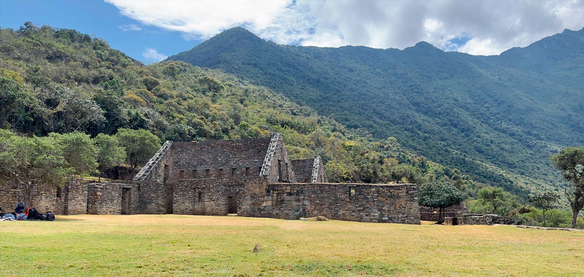
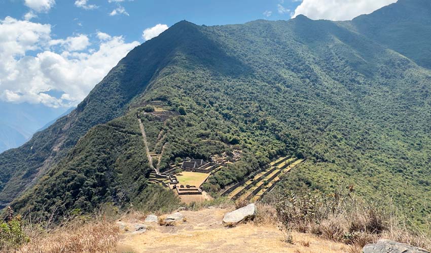
What’s in Choquequirao?
Only 30% of Choquequirao has been excavated, many building still remain covered by dense jungle. In spite of this, it already has several very important Inca constructions:
- Main square – The main plaza divided the site into two. It is a two-story stone construction. Next to it, there are other buildings connected to each other.
- Colcas – Typical constructions of the main Inca centers. In Choquequirao, these platforms have internal subdivisions. The purpose of these deposits was to store products for food, clothing and others.
- Platforms – Choquequirao has an important number of platforms for cultivation. In the western sector there are 22 engravings in the shape of a flame arranged on 15 platforms. These figures are known as the ‘Llamas del Sol’.
- Housing – In the highest part of Choquequirao, there are up to 5 buildings whose purpose was probably housing for the priests of the enclosure. It is believed that this Inca site was an important ceremonial center.
- Inca Cemetery – Also known as the ‘Triumphal Wall’. There were found 17 funerary bales and a water gutter called “The house of the fall of water”.
- Kallankas – These rectangular buildings had multiple functions such as workshop, administrative center, meeting space, etc. In Choquequirao there are 2 Kallankas in whose walls there were gutters that supplied water.
- Ushnu – This oval platform construction is located on the top of a hill. Due to the wall that surrounds it and of the privileged view to the snowed ones, the river and all the enclosure; it is believed that it had a religious purpose.
How to get to Choquequirao?
The only way to get to Choquequirao is by land (hiking). Currently, the main route is going to the town of Cachora (2,903 masl), 3 or 4 hours by road from the city of Cusco (2 hours from the city of Abancay).
Once in Cachora, start the hike to the Inca archaeological site. The route crosses important points such as Capuliyoc, Maranpata, and Sunchupata. It takes about 32 km/20 miles on foot, to reach Choquequirao.
The walking time from Cachora to Choquequirao on average is 10 to 12 hours. A cable car is currently being built which would significantly reduce this time. This project could exponentially increase the visit to this archaeological site. It is expected that with the cable car, the trip to Choquequirao will take only 15 minutes and will have the capacity to carry up to 400 people per hour.
Map Tour 4 days to Choquequirao
How’s the weather?
The archaeological site of Choquequirao is located at 3,033 meters above sea level. The climate is temperate with cold nights. However, the tourist will not remain at the Inca site after sundown.
However, the road that leads to the summit of Choquequirao is hot due to the proximity of the Apurímac canyon. It is estimated that the temperature at the archaeological site varies between 5º C and 25º C.
How is the flora and fauna in Choquequirao?
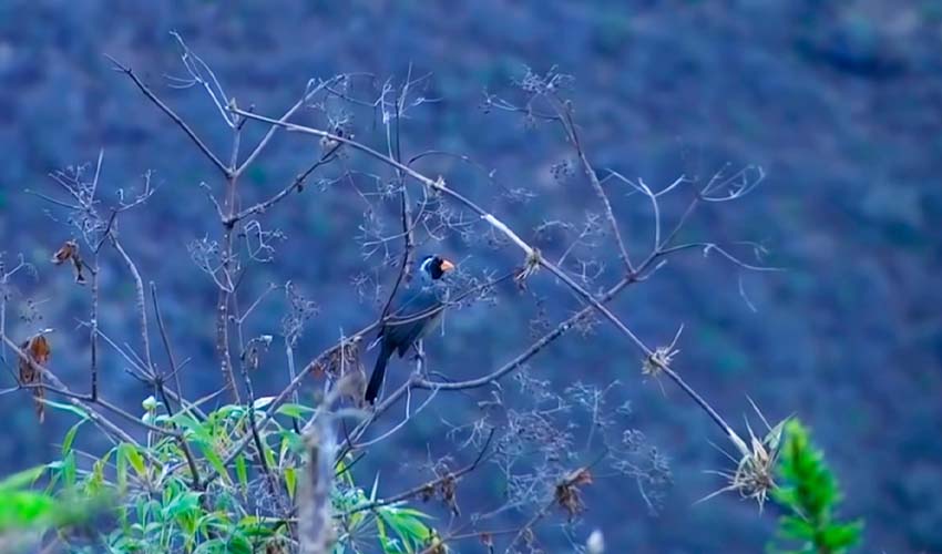
Choquequirao is home to a variety of animals and birds such as the condor, foxes, vizcachas, pumas, hummingbirds, spectacled bears and the cock of the rocks In addition, like Machu Picchu, there is a great variety of orchids.
Trekking route to Choquequirao
Choquequirao Trek 4 days
The most usual way to get to Choquequirao is through the trekking route of 4 days and 3 nights.
Sample Itinerary to Choquequirao 4 days and 3 nights:
DAY 1: CUSCO – CAPULIYOC – PLAYA ROSALINAS – SANTA ROSA
This incredible adventure begins at 4:30am, when the guide will pick you up at the hotel and drive for the next 4 hours in our private van to Capuliyoc (2,850m/9,407ft). Along the way, there are picturesque views of villages, spectacular valleys and snow-capped mountains. Once at Capuliyoc, we meet our horsemen, pack all of our equipment onto the horses. You will carry a small daypack with the essentials you will need on the trail.
Start walking all the way down to Playa Rosalinas (1,475m/4,840ft) where we have lunch. Along the way, you will enjoy great views of the Apurimac Canyon and mountain peaks such as Padreyoc at 5,571m/18,387ft. After lunch, ascend for two hours to our first campsite at Santa Rosa, (1900m/6234ft) where hot drinks and appetizers will be ready. You will have time to settle into your tents, which will already be set up, before dinner.
- Meals included: Lunch – Afternoon Tea Time – Dinner
- Accommodation: Camping facilities
- Distance: 16.5kms/ 10 miles
- Difficulty: Difficult
DAY 2: SANTA ROSA – MARANPATA – CHOQUEQUIRAO
The guide will wake you with a hot mug of tea or coffee to enjoy before you get up. After an early breakfast, we start our adventure by walking for 2 hours to the rural village of Maranpata (2,850m/9,350ft). Enjoy the scenery and walk through an astonishing variety of flora and fauna to the magnificent archeological site of Choquequirao! We have lunch and we will have a private guided tour of the fascinating site in the afternoon.
During the tour, explore all the important sections, such palaces, temples, ritual water fountains, amazing Usnu (ceremonial platform), agricultural terraces, llama’s section and more. The guide will tell you about the fascinating history of this amazing site! Finally, we head back to our second campsite located at Maranpata which is 1.5h from the Choquequirao ruins, where we will have tea time and dinner.
- Meals included: Breakfast – Lunch – Afternoon Tea Time – Dinner
- Accommodation: Camping facilities
- Distance: 16km/10miles
- Difficulty: Difficult
DAY 3: MARAMPATA – CHIQUISCA
After breakfast, descend to the magnificent Apurimac River (1,550m/5,117ft) a walk of about two hours. This is a very sacred river in the Inca culture and you will understand why as you marvel at its strength and power. Finally, we walk up hill for one hour to our third campsite at Chiquisca (1,990m/6,270ft). Once again, your tents will be set up, with hot drinks and appetizers ready.
- Meals included: Breakfast – Lunch – Afternoon Tea Time – Dinner
- Accommodation: Camping facilities
- Minimum Altitude: 1,550m/5,117ft
- Maximum Altitude: 1,990m/6,270ft
- Distance: 12kms/7.5 miles
- Difficulty: Difficult
DAY 4: CHIQUISCA – SAYWITE – CUSCO
After a delicious breakfast, walk up a moderately difficult hill towards the Capuliyoc Pass. Once there, enjoy the spectacular views of the surrounding mountains and the Apurimac Canyon. Then we take our car to Cachora (2,850m/9,407ft) for lunch. Afterward we take our private transport to the archeological site of Saywite taking plenty of time to explore. Finally, our van will take us back to Cusco to the hotel, arriving in the evening, around 6pm.
- Meals: Breakfast – Lunch
- Minimum Altitude: 1,990m/6,270ft
- Maximum Altitude: 2,850m/9,407ft
- Distance: 8km/4.4 miles
- Difficulty: Difficult
**Itinerary provided by Sam Travel
Sample Itinerary: 8-Days Cusco – Choquequirao – Machu Picchu
There is another tour that connects Choquequirao with Machu Picchu in 8 days and 7 nights. In total 115 kilometers of history and adventure are covered.
DAY 1: CUSCO – CAPULIYOC – PLAYA ROSALINAS –SANTA ROSA
The Choquequirao Trek to Machu Picchu is one of the most unique and exciting ways to experience both ancient Inca citadels. The day begins bright and early as your guide picks you up from your hotel at 4am.
We drive for 4-hours to the village of Capuliyoc, situated on the edge of the Apurimac Canyon and surrounded by impressive snow-capped peaks. Here is where the hike begins. We walk downhill for 3 hours until we arrive at Playa Rosalinas.
A delicious lunch awaits us, so fuel up ready for the afternoon. 2 hours of uphill hiking awaits us before we arrive to Santa Rosa (1,800m), our campsite for the evening.
- Meals: Lunch, Afternoon Tea, Dinner
- Accommodation: Camping facilities
- Distance: 18km/11.2 miles
- Difficulty: Challenging
DAY 2: SANTA ROSA – MARANPATA – CHOQUEQUIRAO
We make the most of the day today, kicking off with an early start and starting our 2 hour uphill walk to Maranpata and our first view of Choquequirao. We have another 2 hours before reaching the Choquequirao Archeological site (3,110 meters/10,120 feet).
We set up at the foot of the ruins and enjoy lunch prepared by our talented chef. Then there is nothing to do except explore the site at length. Take as long as you like to discover every nook and cranny of this barely visited site.
Make the most of having the site almost to yourself, and not having to follow the strict government regulations that are imposed on the Machu Picchu site. Be sure to check out the religious area, the observatory area, and llama terraced sections.
We can even enjoy a breathtaking sunset from inside the ruins, watching the sun dip below the valley and mountains. As the sun has set, we return to our campsite for dinner and to get a good nights sleep.
- Meals: Breakfast, Snacks, Lunch, Afternoon Tea, Dinner
- Accommodation: Camping facilities
- Distance: 10kms/6.2 miles
- Difficulty: Challenging
DAY 3: CHOQUEQUIRAO – PINCHIUNUYOC – RIO BLANCO – MAISAL
Today is another early start, so fuel up at breakfast. If you thought that Choquequirao was off the beaten track, be prepared to be amazed at how few people we will see on this route.
We set off from camp at around 6:30am, starting with a 40 minute uphill climb to reach the first pass of the trek: Choquekiraw at 3,500m/11,400ft.
This is an excellent spot to see a wide variety of orchids and flowers, which are almost always in bloom. Then, we continue on a pleasant 30 minutes flat walk, before we head downhill on a zigzag path for about an hour and a half to the Inca site of Pinchauniyoc.
Pinchauniyoc was an Inca agricultural site as well as a rest stop for Incan travelers on their way to Machu Picchu. After a short explanation by the guide, we will continue walking downhill for another hour and a half until we reach the River, Calle Rio Blanco (1,750m/5,741ft)
We will arrive just as lunch is being served, so pile your plate and tuck in- but be sure to bring mosquito repellent for this segment. After lunch, we’ll tackle a 4-hour uphill hike before reaching the campsite at Maisal.
- Meals: Breakfast, Snack, Lunch, Afternoon Tea, Dinner
- Accommodation: Camping facilities
- Distance: 15kms/9.3 miles
- Difficulty: Challenging
DAY 4: MAISAL – VICTORIA PASS – YANAMA
Todays day of hiking begins at 7am with 3 hours uphill. The terrain begins to change from Andean mountain-scapes to sub-tropical vegetation, and we spend more time on an original Inca Trail, passing by ancient silver mines and eventually reaching Victoria’s pass at (4,170m/13,700ft).
From here, we can appreciate the great canyons, and the spectacular snowcapped mountains of Sacsara, Qoriwanachina, and Pumasillo. We finish off the day with a descent to Yanama (3,650m/12,037ft), where we rest and sleep for the night.
- Meals: Breakfast, Snacks, Lunch, Afternoon Tea, Dinner
- Accommodation: Camping facilities
- Distance: 16kms/10 miles
- Time: 8hrs approximately
- Difficulty: Challenging
DAY 5: YANAMA – TOTORA – COLPAPAMPA
Today is another early morning. Have a big breakfast as today we have over 9 hours of trekking ahead of us, passing many snowcapped mountains.
Our first checkpoint is uphill to the highest point of our trek: Yanama pass (4,670m/15,407ft). The view from here is breathtaking with snowcapped mountains and impressive valleys surrounding us as far as the eye can see.
From the pass, we begin out descent to Totora for a delicious lunch. After lunch we have 2 more hours to walk before reaching our campsite at Colpapampa (2,870m/9,470ft).
- Meals: Breakfast, Snacks, Lunch, Afternoon Tea Time, Dinner
- Accommodation: Camping facilities
- Distance: 22kms/14 miles
- Time: 9hrs approximately
- Difficulty: Challenging
DAY 6: COLPAPAMPA – LUCMABAMBA – HOT SPRINGS
Congratulations, we made it to the homestretch! Today kicks off with a mere 3-hour hike through the lush tropical rainforest. We will pass tropical fruit trees, coffee and cacao plants, fruit plantations and blooming orchids.
We arrive to the fabulous Lucmabamaba for lunch, and then have a little time to rest before the afternoon activities begin.
Right next to the campsite there is a coffee plantation where we can learn about the process of making coffee. From the different types of beans to how to pick and process your own, you will learn about every step of the process.
We will also be able to explore the nearby fields of tomatoes and avocados, learn about the ecosystems, and pick our own fresh produce, used by our chef to prepare dinner in the evening.
As 3pm rolls around, we’ll take a local transportation service to the natural hot springs of Cocalmayo, the perfect place to soak your aching muscles after 6 days of hard hiking.
Our return to camp will be celebrated with a meal freshly prepared from the ingredients you gathered earlier in the day. A job well done.
- Meals: Breakfast, Snacks, Lunch, Afternoon Tea, Dinner
- Accommodation: Camping facilities
- Distance: 14kms/8.7 miles
- Time: 5 to 6 hrs approximately
- Difficulty: Challenging
DAY 7: LUCMABAMBA – LLAQTAPATA – HYDROELECTRICA – AGUAS CALIENTES
Our last day of hiking kicks off with another delicious breakfast before we join another ancient Inca Trail. We hike up this trail for 3 hours before reaching the Puncuyoc Pass (2,700m/8,858ft).
From the pass we continue our hike. Along the way, we will have amazing views of unique valleys and fruit plantations. We arrive to Llactapata Inca Ruins, located right in front of Machu Picchu, with views of Huyana Picchu, Machu Picchu and the Aobamba Canyon.
After your guide has shown you around, we descend for 2 hours to the hydroelectric plant, the main electricity source for Cusco, where we will have lunch.
This is the final hurdle, as we walk along the train tracks to Aguas Calientes through the Machu Picchu National Park. The flat walk should feel like almost nothing after the previous days, and it’s the final stretch!
You will start to feel the energy of Machu Picchu as we get closer, and once we arrive to Aguas Calientes you will be able to curl up in a real bed, and enjoy a real, hot shower before an early night ready for tomorrow.
- Meals: Breakfast, Snacks, Lunch, Dinner
- Accommodation: Wiracocha Inn Hotel or Intipunku Tambo
- Distance: 15kms / 9 miles
- Time: 9hrs approximately
- Difficulty: Moderate to Challenging
DAY 8: AGUAS CALIENTES – MACHU PICCHU – CUSCO
We have an early start today, so grab some breakfast in your hotel and get ready to catch the 5:30am bus up to Machu Picchu. This gives you time to watch the sunrise in the magical citadel- the perfect way to start your Machu Picchu tour.
If you have an advanced booking for one of the peaks in the citadel (either Huayna Picchu or Machu Picchu Mountain) you will have time to complete the hike after the conclusion of your guided tour. Once you have had your fill of the citadel (either up the mountains or on the ground) you are free to head back down to Aguas Calientes using the shuttle bus.
Once you arrive in Aguas Calientes you are free to explore as you wish, grab some lunch at one of the many restaurants (not included), visit the market for some souvenirs, or if there’s time, take a dip in the natural hot springs that gave the town its name.
The Expedition train will take you back to Ollantaytambo at 2:55pm or 3:20pm. Be sure to watch the mountains and the Urubamba river from out the window. When you arrive in Ollantaytambo, your driver will meet you at the exit from the train station to take you back to your hotel in Cusco in our private van. You can expect to arrive at your hotel about 7:00pm.
- Meal: Breakfast
- Difficulty: Easy
**Itinerary provided by Orange Nation Peru
What to take on a trip to Choquequirao?
Whether with a tour or on your own, there are some things necessary for all tourists visiting Choquequirao:
- Original passport (it has to be the same as the one used to book the trek)
- Valid university card (if you booked as a student)
- Good daypack
- Water storage: 2-3L reusable bottles (non disposable)
- Comfortable hiking boots with ankle support
- Sleeping bag (can be rented from Orange Nation)
- Headlamp: essential
- Toilet Paper
- Sunscreen.
- Repellent against mosquitoes.
- Hat or cap.
- Sunglasses.
- Sticks for walking.
- Raincoat (in case of rainfall)
When is the best time to travel to Choquequirao?
The best time to travel is between April to October. Choquequirao has two stations:
- Rainy season (from November to March): it is characterized by frequent fluvial rainfall. The sun is not so intense but the rain can make the hike more difficult with slippery paths.
- Dry season (from April to October): it is characterized by the lower frequency of rains. The days are hotter and the nights are colder. However, the low possibility of rain, favors the walk.
Tips to go to Choquequirao
- While you do not need to be an expert mountaineer to visit Choquequirao, it is recommended that you do a little exercise before the adventure.
- Due to the altitude at which Choquequirao is located, altitude sickness or soroche can cause discomfort during the ascent. It is advisable to acclimatize to the climate of Cusco (or Abancay) before starting the trekking.
- Unlike Machu Picchu, Choquequirao receives very few visitors per day.. It is recommended to enjoy the nature and the archaeological site but with responsibility.
More information about Choquequirao
What are the differences between Choquequirao and Machu Picchu?
Choquequirao and Machu Picchu differences
| Data | Choquequirao | Machu Picchu |
| Translated names | ‘Golden cradle’ | ‘Old mountain’ |
| Location | Convención Province – Santa Teresa, Cusco | Urubamba Province – Aguas Calientes, Cusco. |
| Altitude | 3,033 masl. | 2,430 masl. |
| Extension | 3 times bigger and still being excavated | 120 square kilometers and almost fully excavated |
| Function | Citadel and religious center | Citadel and religious center |
| Building date | 1536 AD | 1450 AD |
| Discovery date | 1909 (Hiram Bingham) | 1911 (Hiram Bingham) |
| Entrance ticket | 60 S/. (general admission) | 152 S/. (Machu Picchu ticket only) |
| How to get it? | With a 4-day walking route (round trip) | With a 4-hour tourist train ride (optional 4-day Inca Trail) |
| weather | Temperate (from 5º C to 25º C.). | Warm temperate (from 13ºC. to 26ºC.). |
| Daily visitors | 2,244 tourists (approximately) | An average of only 15 to 20 (approximately) |
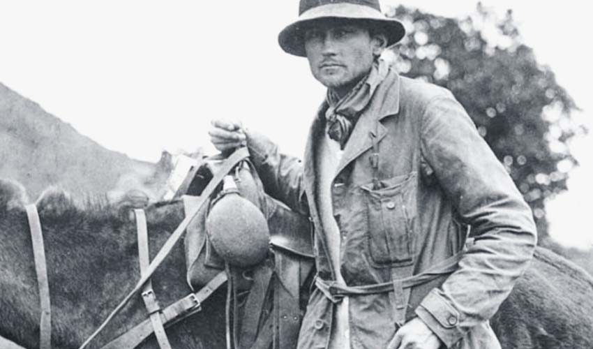
Who discovered Choquequirao?
Like Machu Picchu, many people knew of the existence of the Inca archaeological remains in Choquequirao. However, it was Hiram Bingham who in 1909 rediscovered the site and made its importance known to the world.
However, it was not until 1970 that excavation work began. Currently, it is estimated that only 30% of Choquequirao is unearthed and put on display to the public.
How much does a tour to Choquequirao cost?
The price of a 4-day, 3-night tour to Choquequirao depends on the number of visitors in a group.
Cost of a tour to Choquequirao on average:
How much does a tour to Choquequirao cost?
| Number of days | Price in soles (S/.) | Price in dollars (U$D) |
| 4-Day Trek | 2000 soles S/. | From $537 USD Per Person |
| 5-Day Trek | 2150 S/. | From $577 USD Per Person |
| 7-Day Trek | 3640 S/. | From $977 USD Per Person |
What is the admission schedule?
Choquequirao opens its doors every day from 7 am to 5 pm The ticket allows you to spend the night in a camp located near the Inca site.
What is the difficulty of the Choquequirao tour?
The trekking route to Choquequirao is difficult. From the town of Cachora to the archaeological site, 31 kilometers are traveled to the site and another 31 kilometers on the same route back. The hike includes descent to extremely low altitudes, followed by steep inclines to higher altitudes.
What does a tour to Choquequirao include?
The tour to Choquequirao depends on each tourism agency. In general, these include:
- Transportation from Cusco to the town of Cachora.
- Food (breakfast, lunch and dinner for the duration of the trek).
- Camping equipment
- Mules to carry luggage and camping equipment
- Tickets to Choquequirao.
- Official tourist guide.
- Transportation from Cachora to Cusco.
Questions and answers about the trip to Choquequirao
The route to Choquequirao is done on foot starting from the town of Cachora (165 kilometers from the city of Cusco). The walk is demanding. You travel 32 kilometers until you reach Choquequirao. The return leg is the same.
The archaeological site of Choquequirao is located on the slopes that make up the Vilcabamba mountain range. It belongs to the district of Santa Teresa, province of La Convencion in Cusco. You get there with a walk of 32 kilometers.
The entrance to Choquequirao costs 60 soles for foreign adults and 30 soles for university students.
According to the tour guides who carry out the route, from April to November, which is Peru’s dry season. The walk to Choquequirao is ideal with clear skies and less rain.
A tour to Choquequirao costs from 500 to 1,000 dollars per tourist or even more depending on the tour agency of your choice. The tour lasts 4 to 8 days.
Yes, the route from Cachora to Choquequirao is free for tourists and anyone can do it on their own. But, we highly recommend going with reputable tour agency for this challenging trek.
Yes, the entrance ticket to Choquequirao allows camping next to the archaeological site (in an area designated for camping).
In the rainy season, the walk to Choquequirao becomes more difficult due to the rains that can occur at any time of the day. The rainiest months are January, February and March.
The route to Choquequirao is safe. However, due to the difficulty of its paths, it is recommended to be in good physical condition. This way you can have a much safer walk.
For the route to Choquequirao, do not forget to bring light clothing, comfortable and resistant shoes, a windbreaker jacket, sunscreen, mosquito repellent, a comfortable backpack, a poncho in case of rain, snacks, rehydrating drinks, documents and cash.