Choquequirao to Machu Picchu Trek 2024
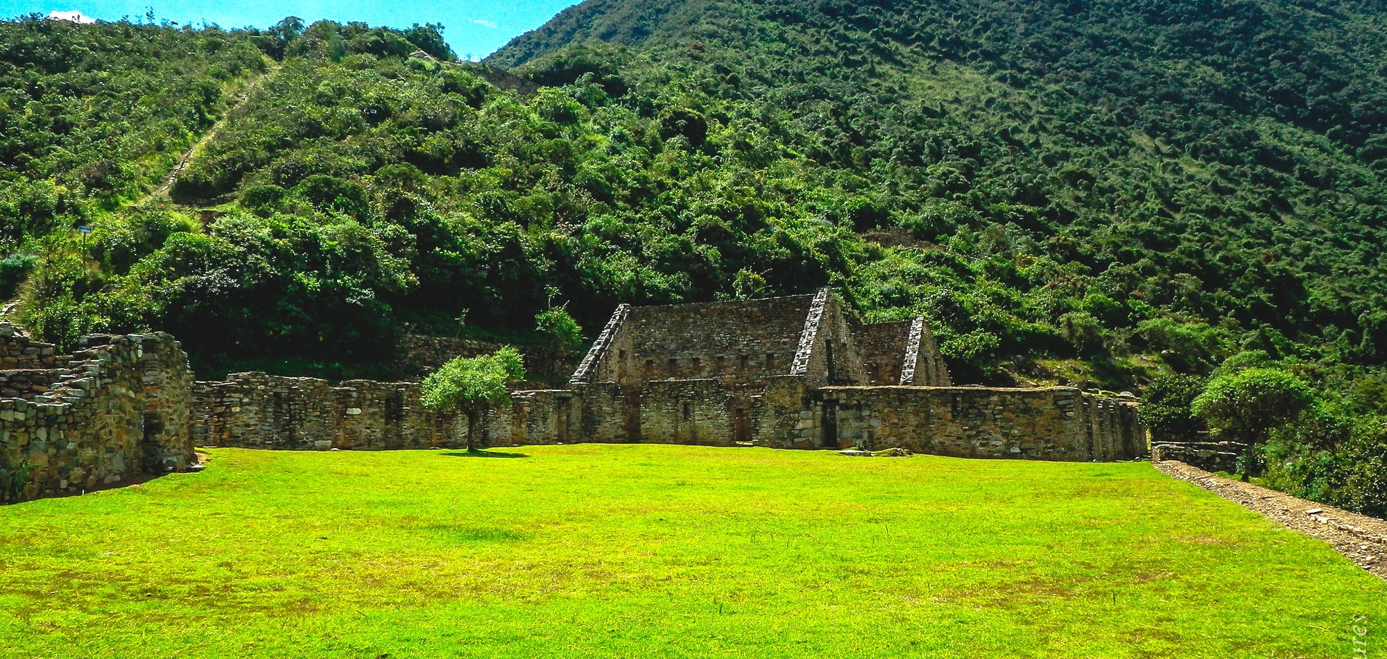
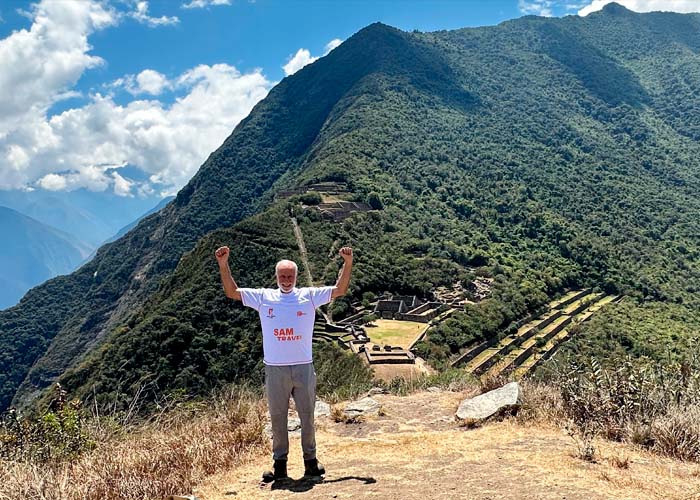
Estled in the lands of the ancient Inca people, the Choquequirao ruins are located 9,800 feet high on lofty ridge above the Apurimac River, 60 miles west of Cusco, Peru. The site of Choquequirao is understood to have been built as a ceremonial site in the late 1400’s under the rule of Topa Inca Yupanki. It was occupied for about one hundred years and the Spanish colonialists never discovered this site. It remained largely untouched until the 1980’s and 90’s when the Peruvian Government decided to begin archaeological explorations. It is an impressive structure built around an upper and lower plaza, incorporating in excess of two square miles. See all the Choquequirao to Machu Picchu Trek deatils.
You may think, why have I not heard of it? Probably the same reason as the Spanish! It is still a multi day challenging trek to reach. Plans are afoot to build a cable car across the valley which will for sure sully the very remoteness that makes this one of the finest wilderness treks on the planet.
Best Months to Trek Choquequirao to Machu Picchu?
The best months to visit are May through to October as it is the dry season.
Why?
Becuase the weather will be good and very few chances of having rain and fog.
How Difficult is the Choquequirao to Machu Picchu Trek?
The total distance of the Choquequirao to Machu Picchu trek is 71 miles. With 7 nights of camping and one night in a hotel. Maximum altitude 15,420 feet and a minimum altitude of 5,118 feet. Temperatures can vary from nights of 4° C (40° F) and days of 29° C (85° F) or more.
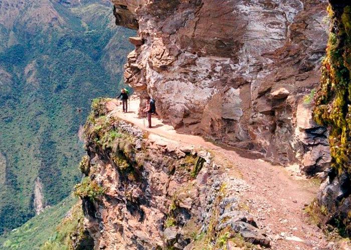
In gradings of 1 easy to 5 very difficult this trek scores as a 4 or above. So yes, you need to be in really good shape to undertake this trek. The main reason is not just the altitude but the undulating route across the valleys. Resilience is also a prime driver of success. The rewards are immense for those that like a challenge, the scenery is a pristine wilderness.
Day to Day Choquequirao to Machu Picchu Trek
- Day 1 – Cusco- Cachora- Chiquiska
- Day 2 – Chiquiska to Choquequirao
- Day 3 – Choquequirao to Pinchaunuyoc
- Day 4 – Pinchaunuyoc to Maizal
- Day 5 – Maizal to Yanama
- Day 6 – Maizal to Totora
- Day 7 – Totora to Lucmabamba
- Day 8 – Lucmabamba to Aguas Calientes
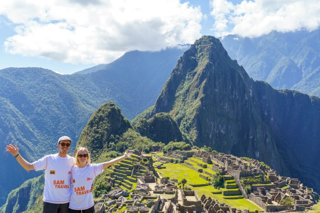
- Day 9 – Aguas Calientes – Machu Picchu – Cusco
ITINERARY
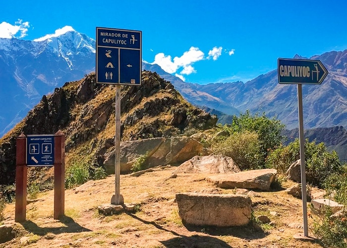
Day 1: Cusco – Cachora – Chiquiska
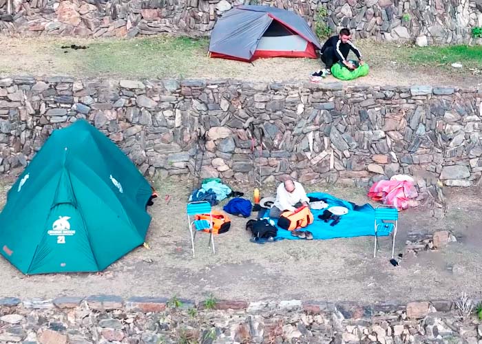
You will be picked up early in the morning from your hotel to head to Cachora, encountering small agrarian villages en route. Here we will see some of the imposing mountains that are part of the Vilcanota range. Then still we will drive for 30 more minutes to Capuliyoc, from where we will have an unbeatable view of the Apurimac River canyon, surrounded by beautiful snowy peaks. Upon arrival, we will have time to enjoy a refreshing lunch surrounded by the beautiful landscapes. From Capuliyoc, we head towards Chiquisca, on the way we will stop at a viewpoint to witness the majestic flight of the condors. Then we continue the journey to your camp. Here, we can enjoy teatime, as well as free time to explore the area or rest. At night we will enjoy dinner under a velvet black sky, before heading to your tent to sleep.
- Maximum height: 10,170 feet
- Minimum height: 6,070 feet
- Walking hours: 4 hrs.
- Walking distance: 9.3 miles
- Campsite: Chiquiska
- Degree of difficulty: 2 out of 5
Day 2: Chiquiska to Choquequirao
We will wake up early in the morning to enjoy an energising breakfast before continuing the walk. We head to the Apurimac River, until we reach the place known as Playa Rosalinas. Here we will have time to prepare before we embark upon the most demanding segment of the entire route. The first part of your walk, about 2 hours, will take us to Santa Rosa Baja and then, we will walk for about 4 hours to Marampata. Upon arrival we will have time for a well deserved lunch. Then continue with the journey to Choquequirao, where the camp will be set up. Once there, you can choose to do an exploration walk to the lower part of the archaeological complex. After a long day of walking, you will have the rest of your time to enjoy tea, rest and finally dine under the stars.
- Maximum height: 9,626 feet
- Minimum height: 5,118 feet
- Walking hours: 5 hrs.
- Walking distance: 6.4 miles
- Campsite: Choquequirao (nearby to, but not at the ruins)
- Degree of difficulty: 4 out of 5
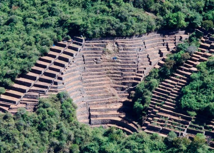
Day 3: Choquequirao to Pinchaunuyoc Ruins
Upon waking up, we will enjoy a refreshing breakfast, savouring the unique from your lofty vantage. We will then walk to the archaeological complex of Choquequirao where, for about three hours, we will learn about the history of this fascinating place. We then navigate to Abra Choquequirao to reach Pinchauniyoc, where the camp will be established in time for lunch. Here, we will have the rest of the time to rest, have tea and take evening dinner.
- Maximum height: 10,945 feet
- Minimum height: 9,350 feet
- Walking hours: 7 hrs (including the 3hr. guided tour of Choquequirao)
- Walking distance: 6.2 miles. (Including the 3hr. guided tour of Choquequirao)
- Campsite: Pinchaunuyoc
- Degree of difficulty: 3 out of 5
Day 4: Pinchaunuyoc to Maizal
Early in the morning we will have time to enjoy breakfast, surrounded by beautiful landscape. We then continue upon the walk that will take you from Pinchauniyoc to Río Blanco. From that point, we will embark on a journey of almost five hours to Maizal, where we camp. Here we will have time to rest, take lunch and, in the afternoon, visit a local family to learn about their lifestyle and customs. The rest of the time will be at your free disposal.
- Maximum height: 10,945 feet
- Minimum height: 6,234 feet
- Walking hours: 5 hrs.
- Walking distance: 3.48 miles
- Campsite: Maizal
- Degree of difficulty: 3 out of 5
Day 5: Maizal to Yanama
After having breakfast early in the morning, we will head to the Victoria mines, where we can observe a fascinating diversity of plants such as orchids and wildflowers. While this route is a quite demanding, the specimens of flora and fauna that you will find along the way will make all the effort worthwhile. Then, we will have time for lunch in an area where we can spot the majestic flight of the condors on the high Andes Mountain range. We will continue your walk for about three hours, finally arriving at the community of Yanama, where camp will be established. In the afternoon, you will live the unforgettable experience of preparing a Pachamanca. A traditional earthen-based cooking method used by the highlanders for centuries.
- Maximum height: 13,780 feet
- Minimum height: 10,499 feet
- Walking hours: 8 hrs.
- Walking distance: 11.2 miles
- Campsite: Yanama
- Degree of difficulty: 4 out of 5
Day 6: Maizal to Totora
We rise to enjoy breakfast and prepare to continue your journey by ascending towards the Yanama pass. From where you can appreciate the majestic landscape of imposing glaciers. In addition, keep your eyes peeled for deer, foxes, birds and other typical species of the area. A great place for photographers. After lunch, we will continue walking towards the Totora community, where camp will best up. We will have the rest of the day free to rest, eat and tour the area before recuperation for the next day.
- Maximum height: 15,420 feet
- Minimum height: 10,499 feet
- Walking hours: 8 hrs.
- Walking distance: 10.6 miles
- Campsite: Totora
- Degree of difficulty: 4 out of 5
Day 7: Totora to Lucmabamba
We leave the Totora community and head to Collpapampa. This segment is done on a paved road, but, when you arrive at your destination, you will notice that the environment changes, becoming greener, as it will be surrounded by typical vegetation of the region. Here you can observe a lot of local flora and fauna and your guide will explain the nuances of each species. Onward to Playa Sahuayaco, passing through some mountains and local villagers’ farms. Here we will have time for lunch before continuing on the journey to Lucmabamba, where camp will be established. This place is full of coffee plantations, and we will give you the option to taste some exquisite Peruvian coffees, which are grown by community residents. At the end of the coffee experience, we will have the afternoon off before enjoying dinner under the stars.
- Maximum height: 11,844 feet
- Minimum height: 6,562 feet
- Walking hours: 9 hrs.
- Walking distance: 12.4 miles
- Campsite: Playa Sahuayaco or Lucmabamba
- Degree of difficulty: 3 out of 5
Day 8: Lucmabamba to Aguas Calientes
We will continue towards Llactapata. From there, we will head to the Machu Picchu Hydroelectric Power Plant, taking an impressive view of the mountains surrounding the Inca citadel. Then, we will have lunch and rest, before boarding the train that will take us to the town of Aguas Calientes, at the Hydroelectric Station. Upon arriving at the place, also known as Machu Picchu Pueblo, you will head to your hotel. You will have the rest of the day off to rest and enjoy the attractions of this picturesque place.
- Maximum height: 8,858 feet
- Minimum height: 6,562 feet
- Walking hours: 8 hrs.
- Walking distance: 6.8 miles
- Note: Option to camp near the hydroelectric station if passengers are willing to walk to Aguas Calientes and Machu Picchu on day 9. Otherwise, overnight at your hotel.
- Degree of difficulty: 3 out of 5
Day 9: Aguas Calientes – Machu Picchu – Cusco
After breakfast, we board the bus that will take us to Machu Picchu and start our guided tour. Your expert guide will educate you on the history, organization, and mysteries of this unique Inca citadel. Afterward, we will have free time to return to the places that impressed you most to take pictures or rest, if you wish. At the end of the visit, you will take the bus to Aguas Calientes for lunch. After lunch, we board the selected train back to Cusco and transfer back to your hotel.
The Choquequirao to Machu Picchu trek Service Includes:
- Pre-departure briefing
- Bilingual guide (Spanish/English) with Wilderness Advanced First Aid Certification (1 guide every 8 passengers)
- Chef and supporting staff
- Transportation to the starting point of the trek (1st day)
- Transportation from Ollantaytambo train station to Cusco Hotel (last day)
- Full meals during the trek.
- Water.
- Complete camping gear: The Eureka tent Four Season or similar, inflatable mattress Therm-a-rest, dining tent, cooking tent, bathroom tent, portable toilets, crockery.
- Bio-degradable dishwashing detergents used by our kitchen staff
- Pack animals (to carry tents, food, and cooking equipment)
- Pack animals to carry personal gear up to a maximum of 7kg per person (including sleeping pad and sleeping bag)
- One emergency horse per every 5 persons
- Horsemen
- First aid kit, oxygen, oximeter.
- Communication equipment: Shortwave radios, satellite phones.
- Expedition train from hydroelectric to Machu Picchu Pueblo (Aguas Calientes)
- Round-trip bus tickets to Machu Picchu
- Entrance fee to Machu Picchu
- Selected train, one way (Aguas Calientes – Ollantaytambo)
The Choquequirao to Machu Picchu trek Service DOES NOT Includes:
- Sleeping bag. Can be included at additional cost
- Tips
- Alcoholic beverages
- Meals in Machu Picchu
- Others not described in the program
Equipment That We Recommend:
- Waterproof hiking boots (preferably a pair that you have worn before)
- Sandals or tennis shoes for comfort while at campsites.
- Long pants
- One T- shirt per day.
- Rain jacket (ponchos), warm jacket, wool gloves, bandana, wool socks, hat, wool cap,
- Swimsuit (if you wish to go to the hot springs in Aguas Calientes)
- Camera, flashlight, head lamp and batteries.
- Walking stick with rubber tip.
- Day pack.
- Insect repellent (minimum recommended 20% DEET) and sun block
- Medicines (in case you have a special requirement)
- Small towel, handkerchiefs
- Toilet paper
- Snacks: biscuits, energy bars, chocolate, raw fruits, muesli, etc. Please note that we do provide a daily morning snack and our meal service is very complete and well supplied. This recommendation applies for all clients being used to a specific snack, as it might not be part of our selection.
- Water container and water for the first morning. Important notice: plastic water bottles are no longer allowed into Machu Picchu. Plastic water containers (ie. Nalgene) or metal ones are recommended
- Cash in soles and/or US$
- Original passport
*All tour routes and contacts are subject to change without notice to maintain the very best client experience.
How Much Does the Choquequirao Trek Cost?
For a 3 to 5-day, standalone trek to the Choquequirao Ruins, you can expect to pay around $500 too $600.
Understandably, the 9-day trek is much more expensive. For this, you will need to budget $1200 or even more. This will include your admission ticket to Machu Picchu.
Be wary of booking cheap tours. When you factor in food, mules, and staff salaries, it is difficult to reduce costs by much.
If the price is too good to be true, there are definitely hidden costs or lack of quality. We recommend you read our article on tipping policy and porter welfare.
Choquequirao to Machu Picchu Trek Overview & Stats
- Point to Point Trail
- The trailhead begins from Capuliyoc and finishes in the small Pueblo of Aguas Calientes, the gateway to Machu Picchu.
- Miles: +/- 78 miles (125.5 KM)
- Trekking Days: +/- 8 Days with day 9 utilized for exploring Machu Picchu
- Total Days: This itinerary is a total of 9 days
- Difficulty: Extremely Difficult due to altitude, remoteness, and not seeing people for days. Never hike alone in the Andes Mountains and be properly acclimated
- Altitude: The section from Capuliyoc to Choquequirao includes a steep descent followed by a steep ascent. Choquequirao ruins are found at an elevation of 10,017 ft (3050 m). The Choquequirao pass to begin the intrepid trek section is 10,735 ft (3272 m) The next two days include two more high altitude passes, the San Juan pass 13,615 ft (4150 m) and Abra Mariano Llamoja 15,289 ft (4660 m).
- Choquequirao to Machu Picchu Trail Markers: The Choquequirao trek is well-marked with blue and white signboards. After Choquequirao, there are random and fewer blue and white signboards. Once the trail merges with the Salkantay trail the path has more distinct signboards